In Partnership With
- Nama Traditional Leaders Association (NTLA)
- Ovaherero Traditional Authority (OTA)
- Forensis
Additional Funding
- Kulturstiftung des Bundes
Collaborators
- European Center for Constitutional and Human Rights (ECCHR)
- Medico International
Forums
At the initiative of the Nama Traditional Leaders Association (NTLA), FA and Forensis worked with descendants of survivors to produce visual evidence and document the oral history transmitted through generations about the massacre of the Witbooi Nama in Hornkranz perpetrated in 1893.
Alongside the spatial reconstruction of the settlement and the unfolding of the massacre, the project interrogates the environmental changes that have ensued since the expulsion of the Nama from these lands.
The project seeks to support the community’s efforts to establish the 1893 massacre of Hornkranz as the first act of genocide against the Nama. It also supports the descendants’ ongoing calls for free and open access to their sites of remembrance.
Findings of this project were first presented at the Inherited Testimonies event at Haus der Kulturen der Welt in Berlin on 3 December 2023. This work constitutes a part of the second phase in an ongoing project investigating the German colonial genocide in Namibia. View phase 1 of our investigation.
Introduction
On 12 April 1893, German colonial troops attacked the Nama settlement of ||Nâ‡gâs, known today as Hornkranz. Their intent was to destroy the settlement and its people, after its leader, Hendrik Witbooi, refused to sign so-called ‘protection’ treaties—tools of the German colonial administration for controlling sovereign indigenous nations and their lands. As their presence in what they declared in 1885 as ‘German Southwest Africa’ grew, the German regime was increasingly unwilling to tolerate the independence and agency exercised by Hendrik Witbooi and his clan in the face of the encroaching German empire.
In their attack on Hornkranz, the Germans wanted to both make an example of the Witbooi clan and to punish them for their defiant rejection of German rule. Curt von Francois, who led the attack, made his objective clear: ‘to exterminate the Witbooi tribe’ (Bundesarchiv, R 1001/1483, p. 46). In this premeditated act of erasure, his troops massacred almost eighty women and children before capturing another hundred, burned what remained of the settlement to the ground, and established a garrison, rendering it impossible for survivors to return.
Though the genocide of the Nama, Ovaherero and other peoples indigenous to what is now modern-day Namibia is widely recognised to have taken place between 1904 and 1908, the Nama people remember this massacre as the true first act in the genocide against them. This is substantiated not only by the clarity of the German objective to destroy the |Khowesin as a people, but also by the retrospective reading of Hornkranz as a clear precedent of the systemic tactics of dispossession and destruction that would be used by the Germans against the Nama, the Ovaherero, the San, and others in the years to come.
Outside of the descendant communities, the events at Hornkranz have until now been overlooked and underrepresented, as has the cultural significance of the settlement itself within the dominant historiography, broadly based on the German visual and narrative record. The site of the former Witbooi settlement was expropriated and today constitutes a private farm, access to which is possible only with special permission from its owner. The descendants of Hornkranz are rarely able to visit their own cultural heritage sites and commemorate the struggle of their ancestors.
The faint extant traces of the Witbooi settlement at Hornkranz can be identified today only with the guidance of the descendants and the historians that learned from them. Two plaques on the site are the only indications of the Nama presence on that land. One plaque was inaugurated by the community in 1997, the only occasion on which they were able to gather to commemorate the massacre at the site where it took place. The other plaque (date unknown) glorifies the German troops, even going so far as to include an offensive slur for the Nama; the massacre is described as a ‘battle’, conveying little of the atrocities perpetrated there.
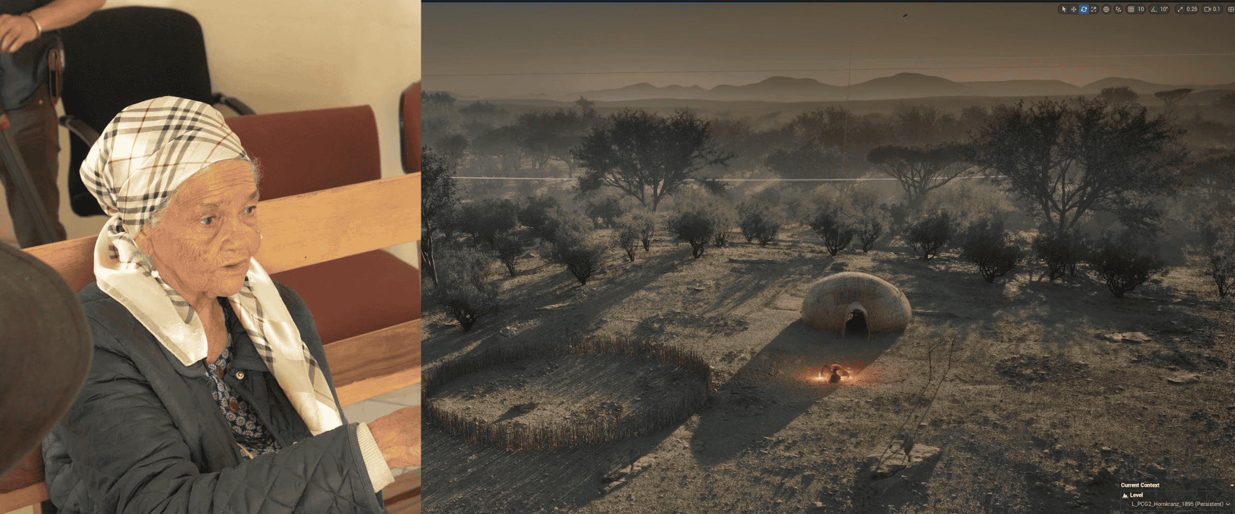
The descendants of Hornkranz and the wider Nama community continue to struggle for justice and for opportunities to correct the historical record and tell the story of Hornkranz on their own terms. In support of their efforts to resist this erasure, we worked with descendants, who have inherited knowledge of their community’s history through oral transmission over multiple generations, to reconstruct the lost settlement and produce a new body of visual evidence about the massacre and its aftermath. Led by their testimonies, we used modelling and mapping techniques along with our own field research and a very limited archival record to situate their accounts and rematerialize Hornkranz.
Our reconstruction of the Witbooi settlement at Hornkranz aims to underscore the vitality of oral tradition in the act of reconstituting the colonial archive and testifies to the oral transmission of inherited knowledge as an ongoing act of resistance in itself.
Background
The |Khowesin (Witbooi) people, a semi-nomadic subtribe of the wider Nama peoples, settled around the perennial spring at Hornkranz in 1884-1885, the very period during which the Berlin Conference, formalising the fragmentation of Africa into colonies and protectorates, was taking place. The chief of the Witbooi clan, Hendrik Witbooi, later went on to become one of the most prominent figures of anti-colonial resistance in Southwest Africa, uniting all Nama clans and later forming a coalition with the Ovaherero to fight against the German colonial regime.
Following the establishment of their settlement in Hornkranz, the Witbooi Nama lived relatively undisturbed until 1892, when first attempts to compel Hendrik Witbooi into signing a protection treaty began. Hendrik Witbooi, aware that the true objective of the so-called ‘protection treaties’ was nothing short of subjugation, was the last leader to refuse to comply:
What are we being protected against? From what danger or difficulty, or suffering can one chief be protected by another? […] I see no truth or sense, in the suggestion that a chief who has surrendered may keep his autonomy and do as he likes.
The German attempt to secure control over the peoples inhabiting the colony and their land is manifested in their mapping efforts. The first map we found featuring Hornkranz dates to 1892, the same year that the Germans began demanding the Witbooi sign such treaties. Despite Witbooi’s refusal to sign, Hornkranz is labelled in these German maps as ‘proposed Crown Land’ already six months before the attack—the very act of cartographic representation prefiguring the expulsion and massacre to follow less than a year later.
After the Germans attacked Hornkranz, the Witboois were finally forced to concede and sign one of the protection treaties they had so long been resisting.
A decade later, in 1904, the Nama joined the Ovaherero in an anti-colonial struggle against German rule. In response, the Germans issued an extermination order against the Ovaherero and later, another against the Nama. Hendrik Witbooi died in battle on 29 October 1905. Following his death, the Nama tribes surrendered. The extermination order against the Nama was never revoked.
12 April 1893: The Attack and Aftermath
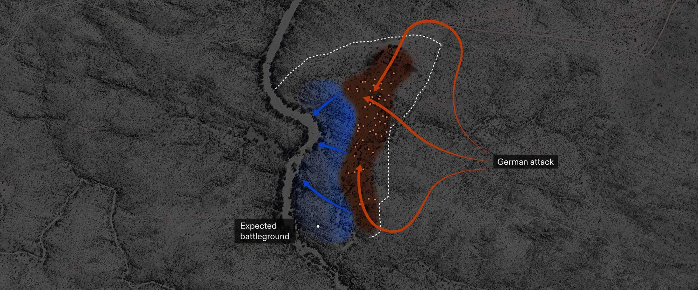
The German troops approached the settlement in the early hours of 12 April, planning to attack under the cover of night without any warning. They then split into three contingents—a recounting of this strategy is recorded in the diary of Kurd Schwabe, one of the perpetrators of the attack. Von Francois led the attack from the northern side, entering the village first, while Schwabe approached from the east.
Hendrik Witbooi, who was allegedly sitting outside of his house when he noticed the approaching troops, ordered all Nama fighters to retreat and take up defensive positions along the riverbed, where he expected the ensuing battle to take place. Instead, the German troops stopped when they reached the sleeping village and proceeded to target the defenceless population that had stayed behind. The brutality of the onslaught came as a shock to Hendrik Witbooi, who had not expected the Germans to unleash such ‘uncivilised’ tactics upon another sovereign nation.
Sixteen thousand rounds of bullets were reportedly discharged by the Germans in the span of just thirty minutes. According to the testimony of descendants and corroborated by Schwabe’s diary, some victims were burned alive in their homes.
The canisters recovered from the site during our fieldwork in September 2023 indicate where some exchange of fire may have taken place while the Witbooi fighters were retreating. While the found bullets were identified as those used by the Witbooi Nama, their location and distribution also corroborates written descriptions of the massacre unfolding in the inhabited area of the settlement, with stored ammunition exploding from inside the burning houses.
The massacre yielded 88 victims: ten men, including one of Hendrik Witbooi’s sons, and 78 women and children.
The following day, the German troops returned to raze what remained of the settlement to the ground. Promptly after, a garrison was established on the ashes of the Witbooi settlement, reinforcing the Germans’ clear intention to claim the land and prevent the Witboois from ever returning.
Over the next year, the Witbooi Nama made several attempts to return to Hornkranz, resulting in four more skirmishes on the site. Eventually, they were forced to sign a protection treaty in Naukluft in August 1894, which cemented the dispossession of their land.
The treaty meant that the Witbooi Nama were now obliged to assist the Schutztruppen in their battles against other tribes, most devastatingly at the Battle of Waterberg in August 1904 (see our Phase 1 investigation of this event). Once the Nama realised the true genocidal intent of the Schutztruppen, they united with the Ovaherero against colonial rule. The extermination order against the Nama was issued on 22 April 1905.
After the genocidal war ended in 1908, Hornkranz was sold off to a private owner and a police station was established on its premises. Today, the police station building is the main farmhouse.
Nama descendants are seeking to establish the 1893 massacre as the first act of genocide against the Nama, and 12 April as the official Genocide Remembrance Day in Namibia.
This investigation—part of a larger collaboration between Forensic Architecture, Forensis, Nama Traditional Leaders Association (NTLA) and Ovaherero Traditional Authority (OTA)—seeks to support the community’s broader efforts to make the site accessible for commemoration and preservation.
Ecology: From Stewardship to Ownership
The project seeks to demonstrate what the descendant communities have always known: that colonial violence and environmental collapse are deeply entangled.
To understand the full extent of the violence inflicted by the massacre and displacement of the Nama from Hornkranz, we interrogated the environmental change that ensued as a consequence of their expulsion and subsequent expropriation of their ancestral land.
The Nama’s ancestral ways of life were attuned to the environment’s rhythms, dictated by the availability of water and long-term recovery of grazed vegetation. These practices, and the lifeworlds that supported them, were obliterated by the colonial genocide and the expropriation of ancestral land, along with its cattle.
To understand the environmental changes the land has undergone and been subjected to between 1893 and the present and reconstruct the vegetation cover at the time of the attack, we deferred to the oral history transmitted by the Nama descendants with whom we were collaborating.
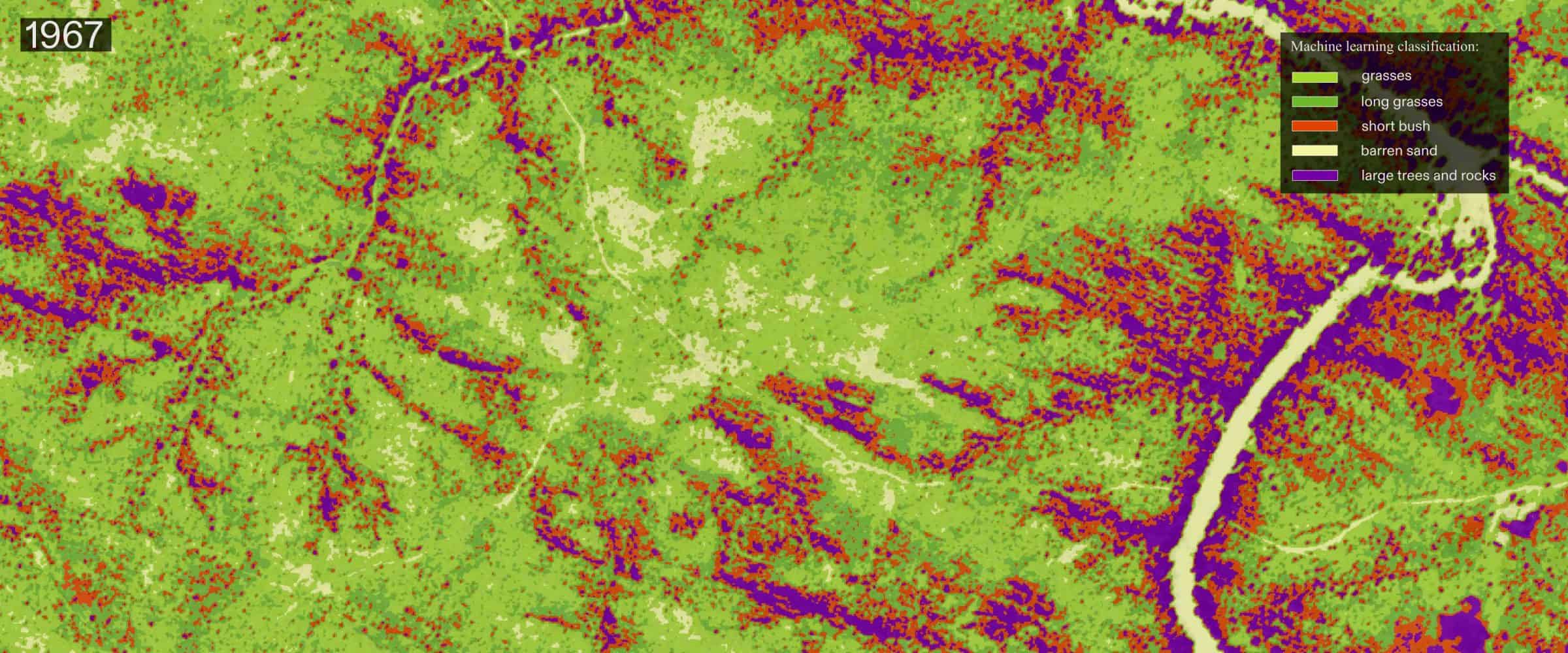
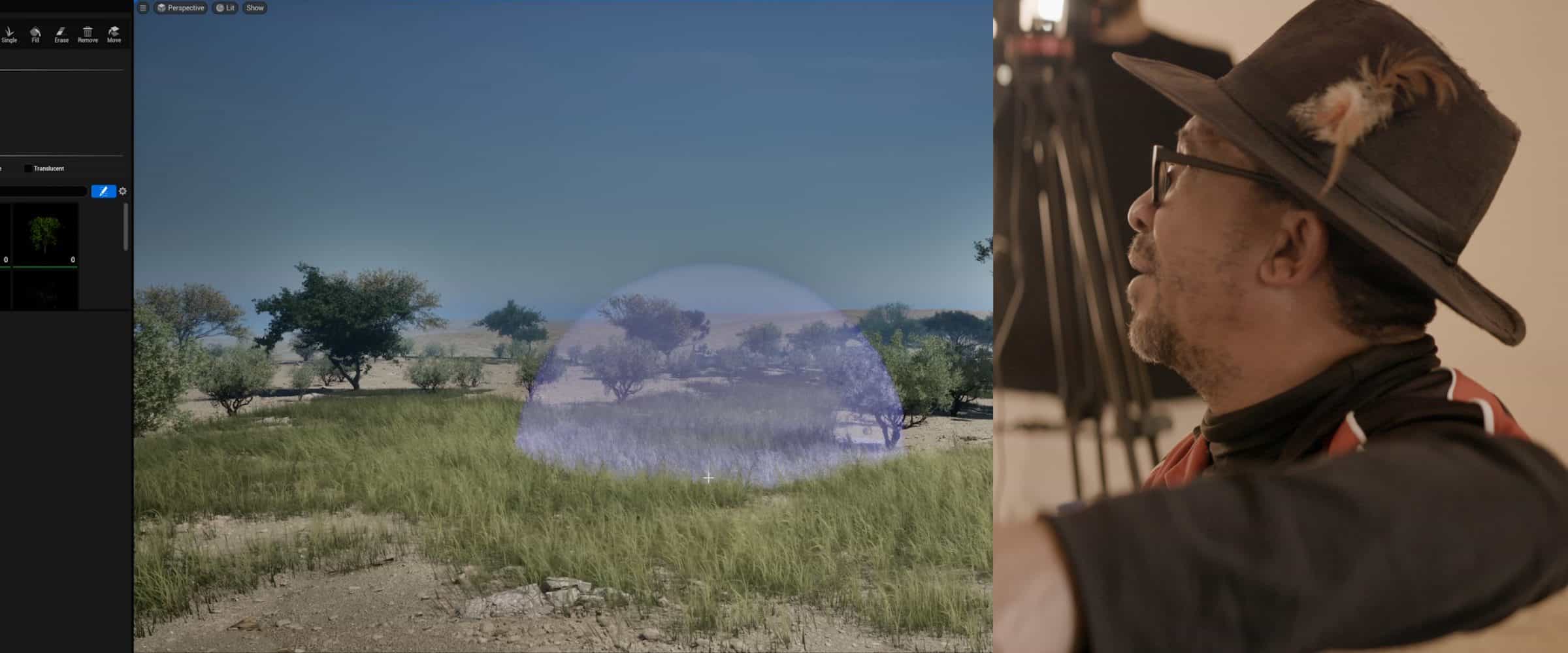
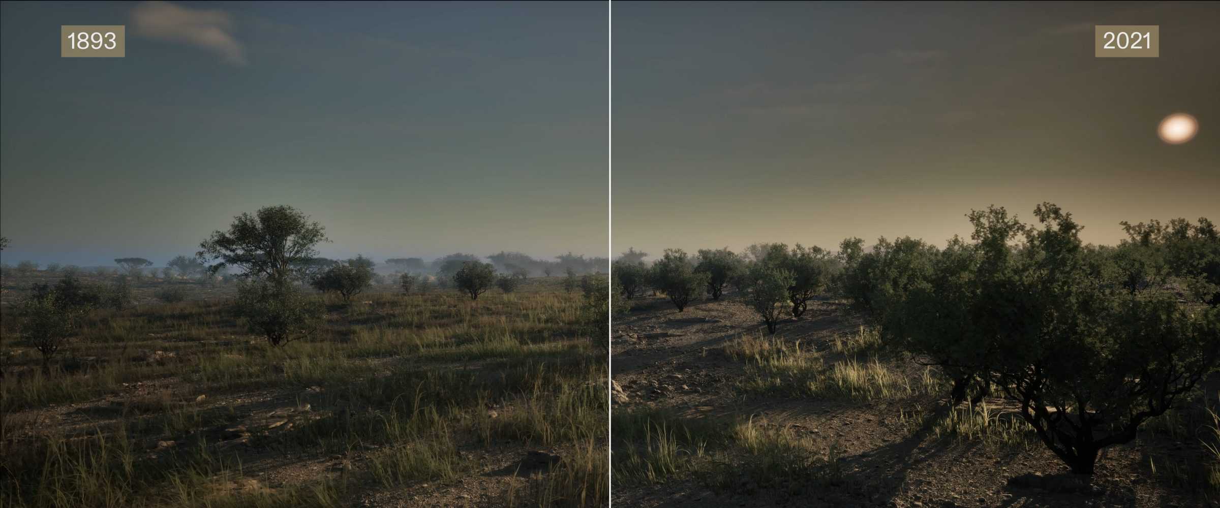
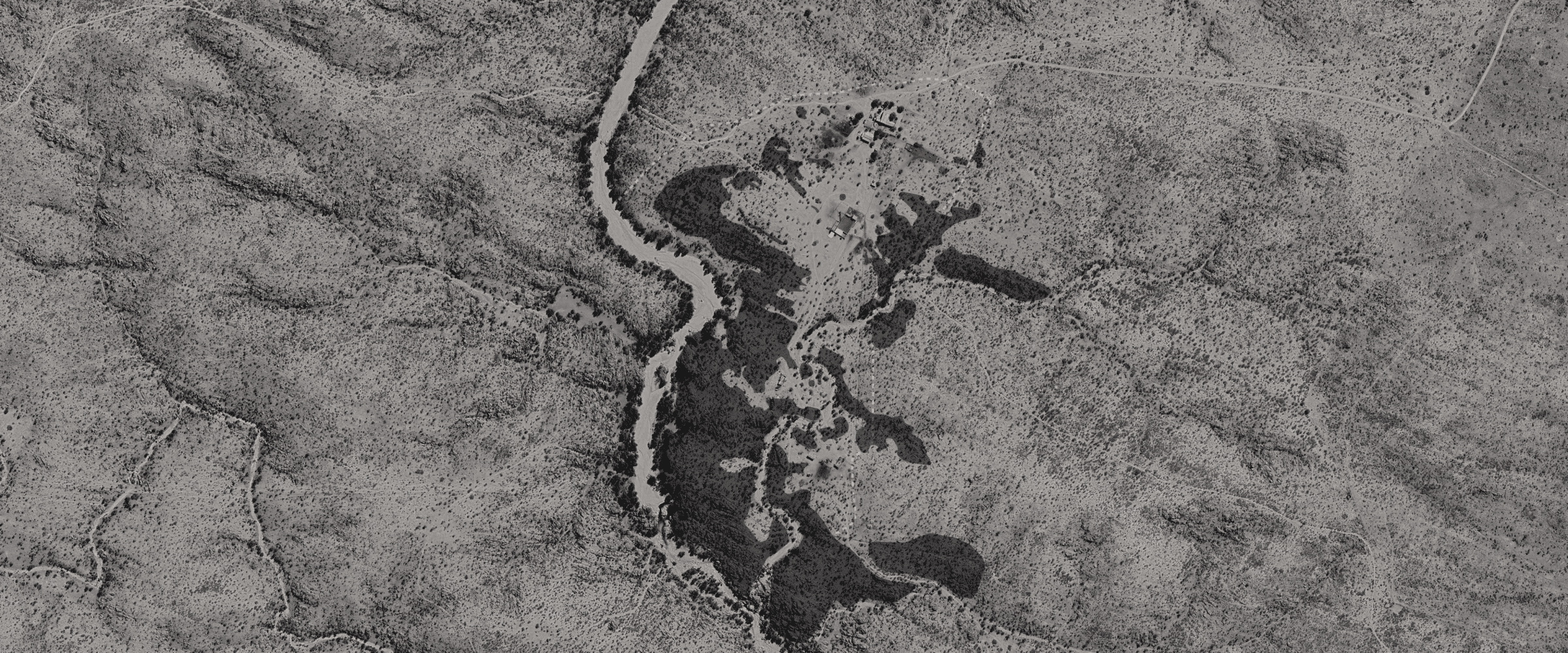
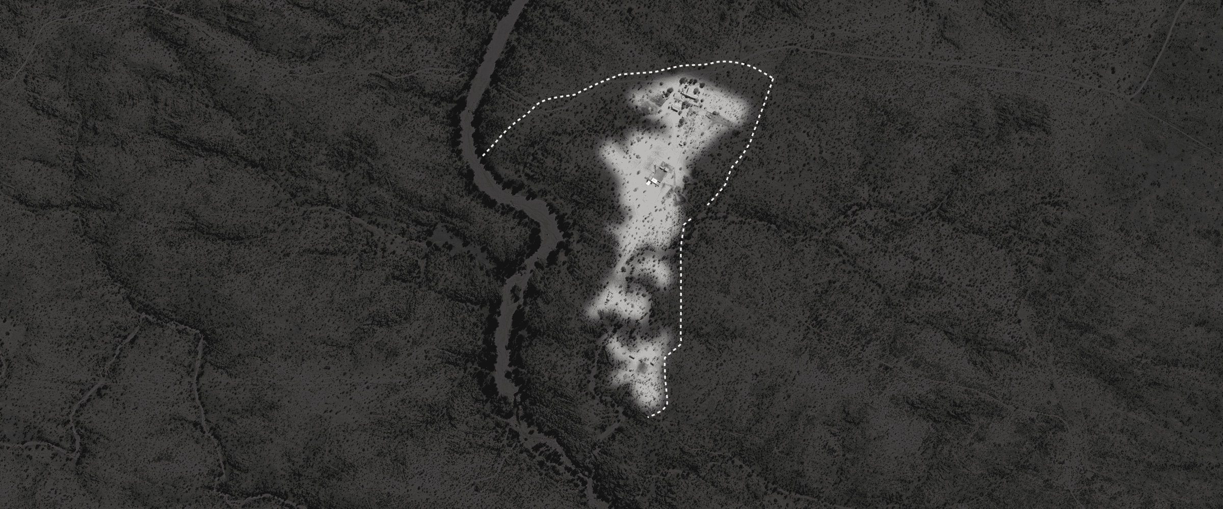
We then tracked the change in vegetation between 1967—when the earliest aerial photograph of Hornkranz was captured—and today. To analyse the 1967 image, we used a machine learning algorithm to classify pixels on the grayscale range into distinct categories, reflecting the presence of grasses, woody vegetation (such as thorny bush) and bare ground. Conducting a similar process on a contemporary satellite image reveals a stark difference in the presence of woody vegetation.
The process whereby thorny bush cover spreads across the landscape at the expense of grasses is known as bush encroachment. Across Namibia, this phenomenon is exacerbated by overgrazing, with devastating consequences for the biodiversity of grassy savannas.
The transition of Hornkranz from indigenous habitation to colonial habitation is underscored by two main factors: the introduction of private property and fencing, as well as the presence of dams to sequester previously freely accessible water sources for use on individual farms.
Methodology
Methodology
What Remains
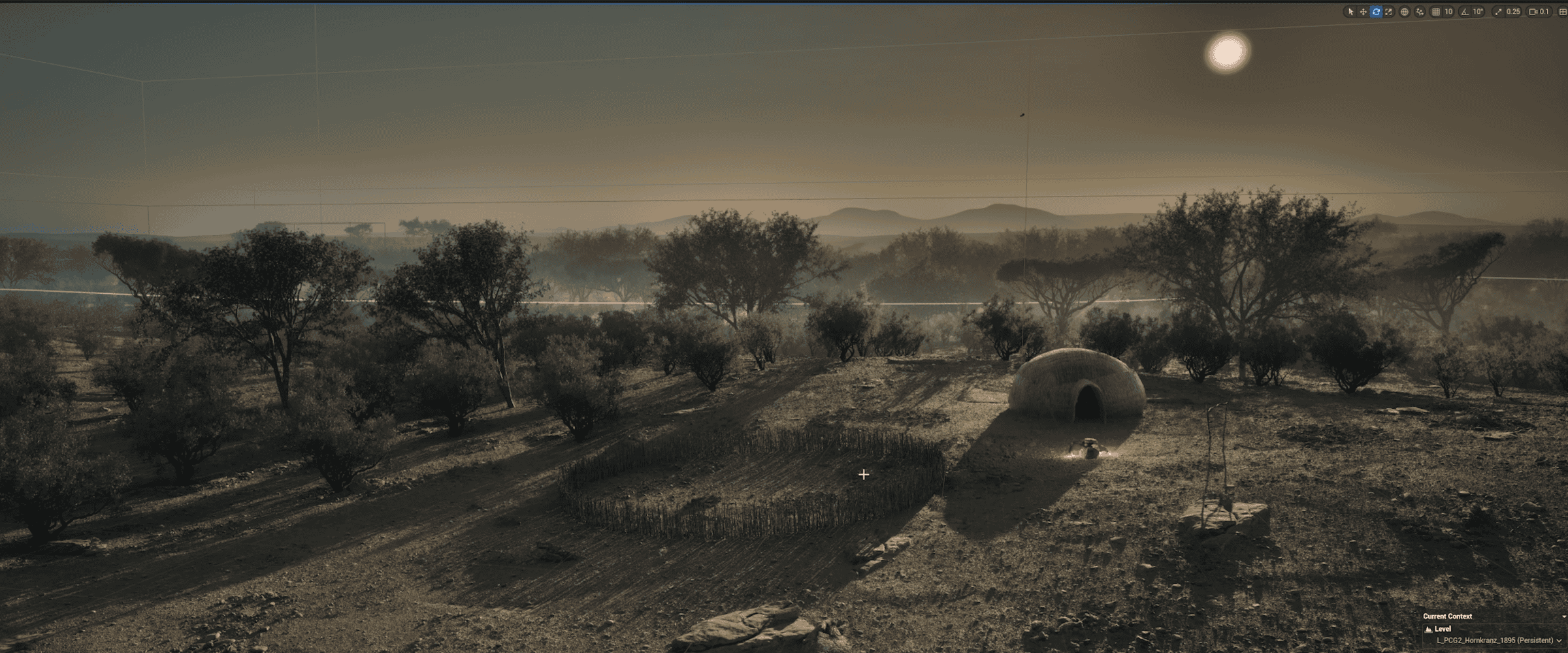
Little material evidence of Hornkranz survives today. This is in part due to the scale and totality of destruction by the Germans; but it is also a testament to the Witbooi’s steadfast resistance to being documented by the colonial regime, as well as to the light footprint the Nama exerted on the land through their semi-nomadic inhabitation and subsistence. The archival record about the Witbooi and Hornkranz is also sparse and skewed. Alongside an incomplete and biased colonial description of the massacre and the settlement, the only visual representation of Hornkranz on record is a soldier’s crude sketch showing its houses set alight by the German troops on the night of the massacre. The memory of Hornkranz as it was at the time of the attack lives on instead through the descendant communities who have inherited the testimonies of their forebearers about its material culture, rituals, life and environmental practices; our reconstruction and understanding of Hornkranz is possible only insofar as we are led by their testimonies.
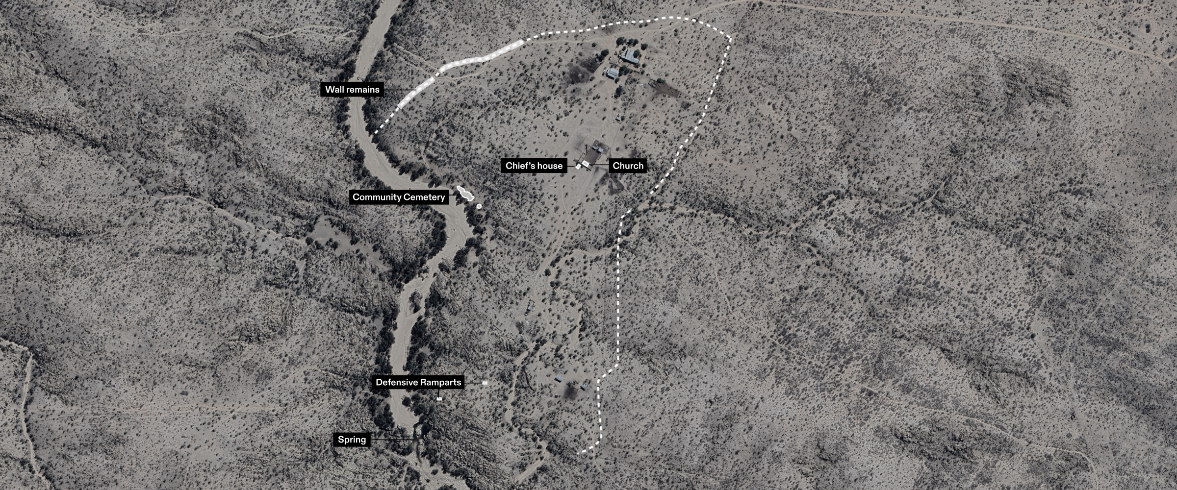
Around the rectangular patch where Hendrik Witbooi’s house once stood, Maboss Ortman and Lazarus Kairabeb, NTLA advisors, identified stones they said are the ruins of the house. Right next to it is the only stone foundation in the settlement, that of a church still under construction at the time of the German assault. These two traces anchored us spatially when we began the 3D reconstruction. We were told by Zak Dirkse, a Nama historian, that Hendrik Witbooi’s house was located higher up in the settlement, with the other houses further down toward the river.
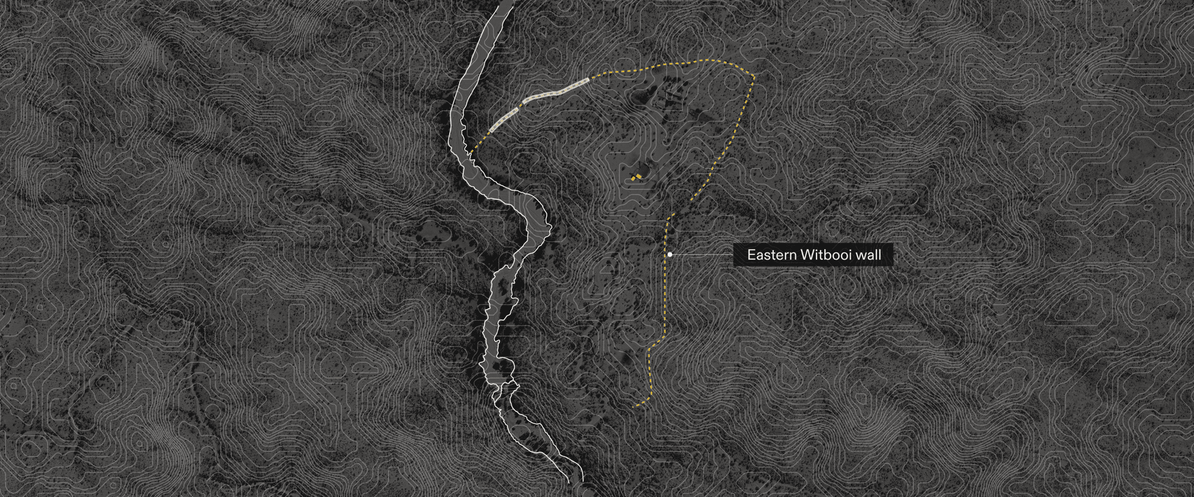
The other remains and known landmarks of the original Hornkranz settlement help us to navigate it and determine its approximate boundaries. During our visit to the site, the farm owner pointed us to a long strip of clustered stones he explained were the remains of the settlement’s defensive walls, some 300 metres north-west of the church ruins. To the south, by the river, the settlement’s former cemetery is marked by the spread of small rectangular cut stones marking each grave. Further along the river, Maboss and Lazarus showed us the remains of two defensive ramparts, guard outposts downhill from the settlement on its outer edges. They recounted that these ramparts were identifiable to the Witbooi from a distance by a white cornerstone that stands out among the brown stones the rest of the rampart is made of. The ramparts are placed along the hill leading down to the river and would have had a wide lookout view. A few steps to the west of one of the ramparts, we found what brought the Witbooi to this area, a rare perennial spring, which acted not only as a fresh water source for the village, but as a lifeline to the fauna and flora on which the Witbooi relied to survive. Since the early 20th century, this spring has been surrounded to its north by a concrete dam. By establishing this constellation of remains and landmarks, we were able to clarify the approximate outer edges of the settlement.
Reconstruction
To reconstruct the Hornkranz settlement, departing from the few architectural landmarks at our disposal, we replicated the architecture of each house and the elements of family life around it, estimated the area of inhabitation within the settlement, and constructed possible layouts of house distribution within the settlement. This reconstruction was led by the close guidance of descendants of the Witbooi we met with in Gibeon, the expertise of Nama historian Zak Dirkse, and the feedback of the Witbooi Royal House council, the representative body of the Witbooi Nama. Our model represents the most comprehensive visual reconstruction of the Witbooi settlement to date.
Architecture of the Settlement
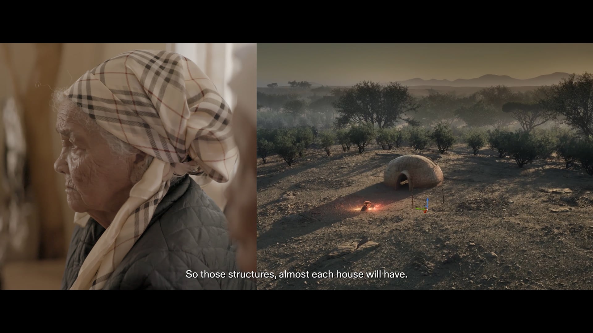
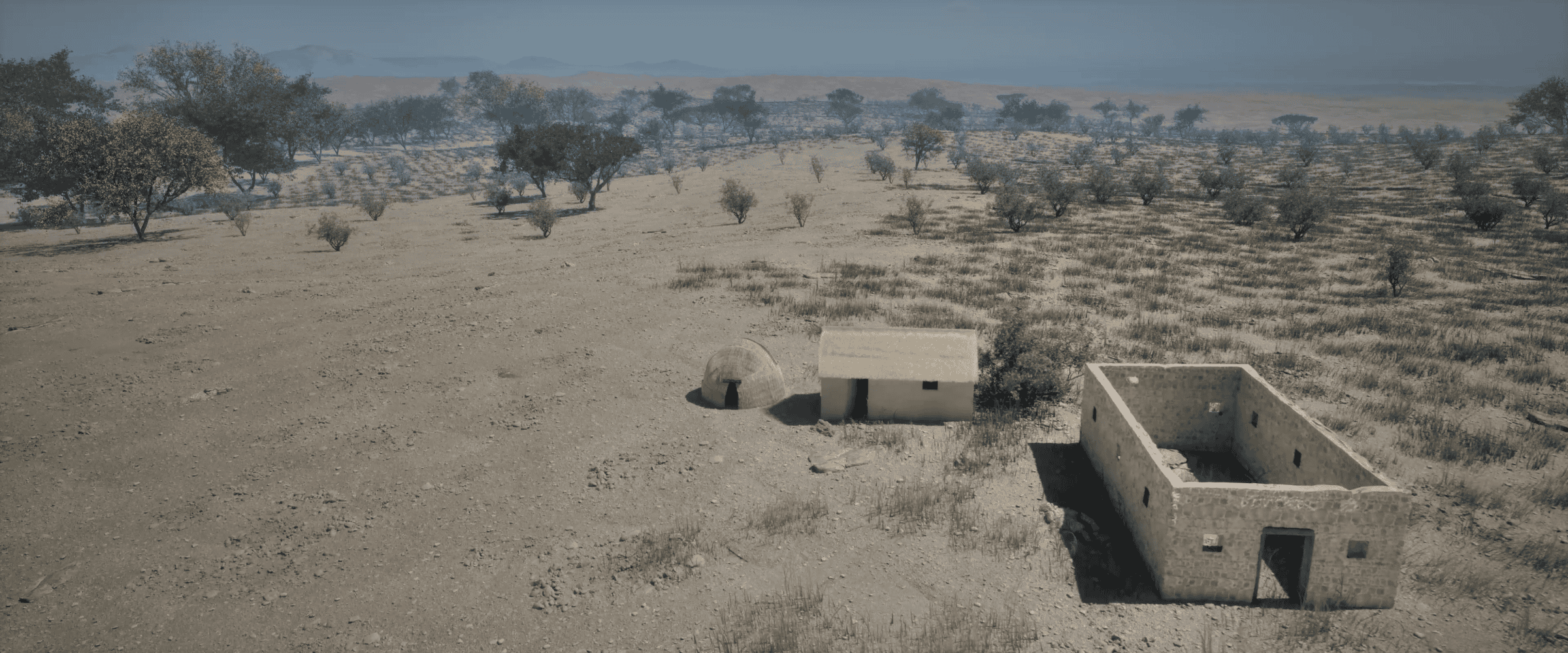
Houses in Hornkranz consisted mostly of round domed huts, between four and five metres in diameter, and constructed with cladding made out of reed mat or a mix of animal dung and clay. Zak explained that these huts would have been constructed on a light foundation made up of the same dung and clay mixture spread on the ground. A central pole would act as the main structural pillar on which the reed mats would rest. According to members of the Witbooi descendants, alongside these huts there would have been other houses built of stone, like that of Hendrik Witbooi. Descendants also explained that houses typically had two entrances opposite one another and positioned on an east-west axis with the main entrance facing east.
Working with the community descendants and Zak, we used 3D modelling software to reconstruct what a typical family home would have looked like. We were told that outside the houses, many families would have had a round kraal lined with a light wooden fence where they kept smaller livestock. Close to the main entrance, they would also have had a fireplace and a simple wooden rack to hang and dry meat. The main kraal of the settlement was near the chief’s house, where a separate storage hut also stood.
The light environmental trace of the Nama, the German colonial army’s obliteration of the settlement, the failure of subsequent administrations to engage in preservation efforts, and the conversion of the land into a private farm all make it difficult to locate definitive traces of the layout and location of homes based on what little remains at the modern-day site. Nevertheless, by closely reading the texture of the ground, we found possible traces of cleared, round areas surrounded by larger rocks, and noted areas of sparse vegetation growth, a potential indicator of the impact of the huts’ clay-dung foundations. We marked five possible sites where Witbooi homes might have stood.
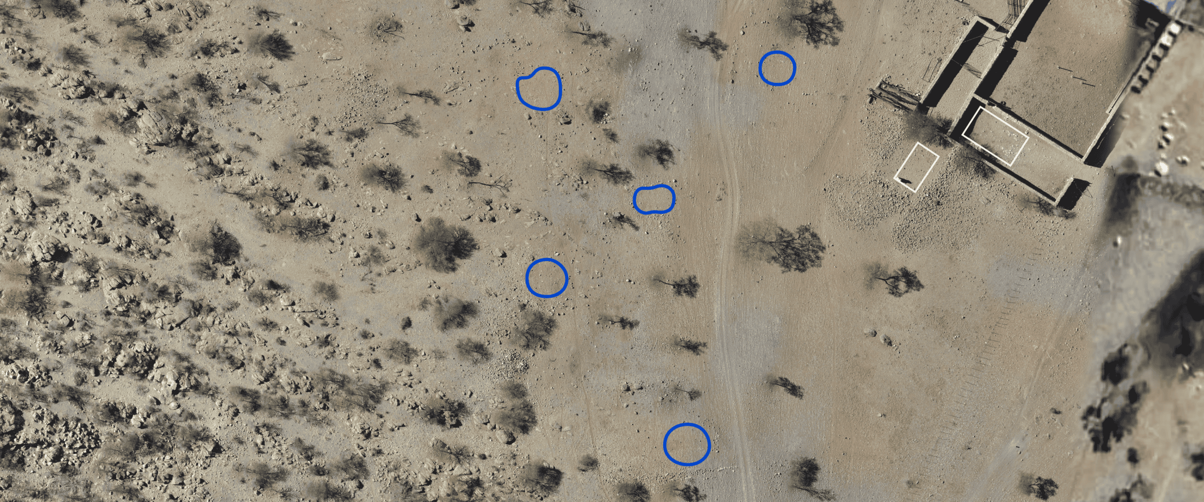
Zak explained that a defensive wall would have flanked the settlement along its more vulnerable northern and eastern fronts. We studied the contours of the landscape to estimate, based on the presence of limited remains, how the wall might have cut through the landscape. We estimate that the eastern wall may have been constructed along the peak of the hill to the settlement’s east, given its optical reach and defensive position.
Area of Inhabitation
To estimate the area of inhabitation and the settlement’s population, we studied the remaining ruins of the settlement, the terrain of the landscape, and the land’s geological features.
Houses, we were told, would have been built on flatter ground. We used a 12.5 metre resolution digital elevation model (DEM) to build the terrain in our 3D model and further analysed it in geographic information system (GIS) software. From the DEM, we extracted the contour lines of the landscape and conducted a slope analysis, which calculates the percentage of slope change in the settlement. Analysis of the contours and the areas of low slope help to define the curvature of the settlement’s inhabitation.
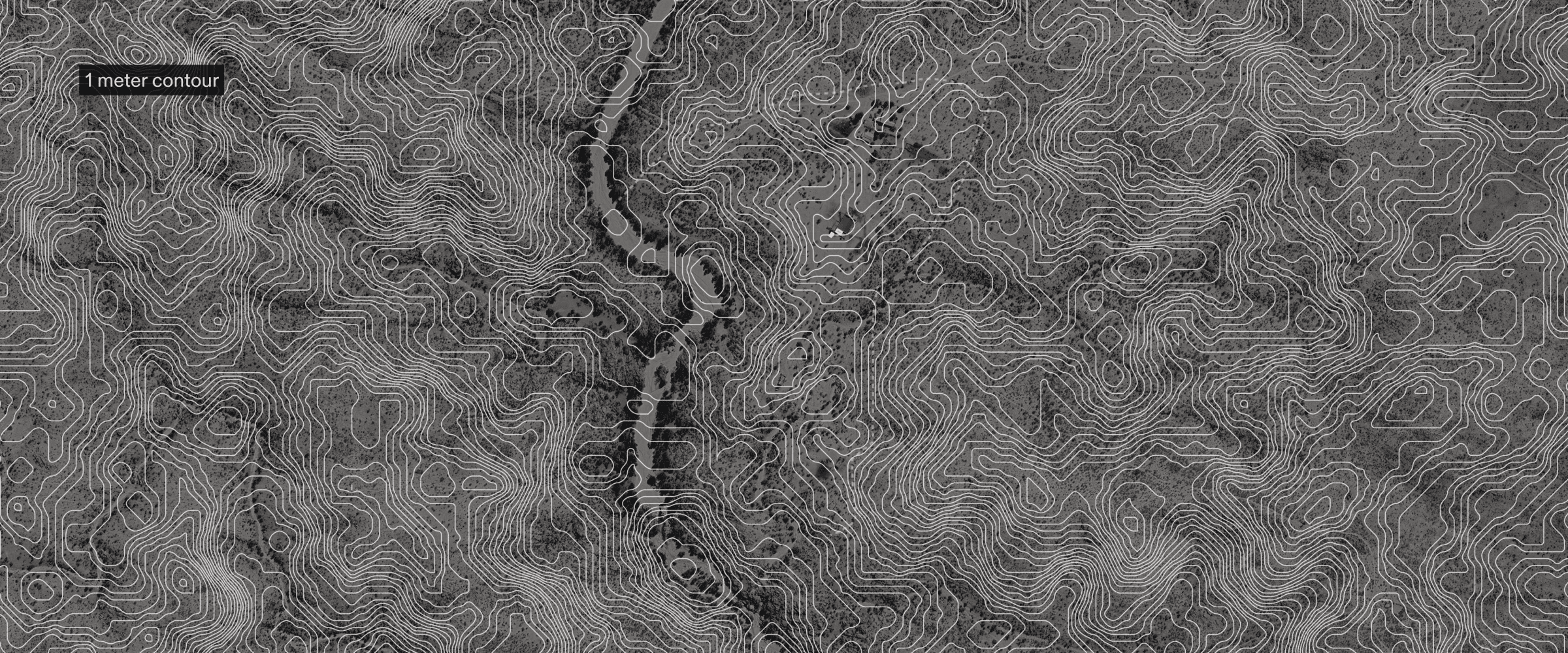
We then traced and excluded uninhabitable geological features from the area of potential inhabitation, including bodies of water and large embedded rock formations. Together, the land’s features, its topography, and our estimated location of the defensive wall help establish where people may have lived.
Layout of Hornkranz
Building on the traces of potential houses we previously identified within the landscape and the descendant’s description of the settlement, we were able to algorithmically model potential layouts of the settlement. We used the 3D procedural modelling software application Houdini to design an algorithm that would generate possible layouts of the settlement according to a set of rules, including our defined area of potential inhabitation and the approximate space each household would need for its family life (which we approximate to be a radius of 10 metres). The rules fed to the algorithm were that the houses had to be at least 20 metres apart, each house was approximately 5 metres in size, and there were sixty houses in total with a deviation of +/- ten houses.
According to the Hornkranz descendants, there would have been around four to six people per household. With an average of five people per household, we estimate the population to be around 300 people per household.
Number of inhabitants
The exact population size of Hornkranz at the time of the attack is not known. Sources provide estimates ranging from 250 up to nearly one thousand inhabitants.
In addition to the members of the |Khowesin Nama clan, Hendrik Witbooi also gathered followers from other clans at Hornkranz, including the ǀAixaǀaen (Afrikaner Oorlams), ǁKhauǀgoan (Swartbooi Nama), Khaiǁkhaun (Red Nation Nama) and ǂAonin (Topnaar Nama). Indeed, the various Nama subtribes were elastic social entities.
We estimated the 1893 population of Hornkranz by referencing the reported number of individuals killed and captured. Hendrik Witbooi wrote in his diary that 88 people were killed by the Germans that day, 78 of them women and children and ten of them men, with one hundred women and children captured by German colonial forces. Other sources indicate a similar number of casualties: 85 women and children, and ten men (Missonary Olpp, cited in Steinmetz 2009). Descendant narratives also mention the successful escape of some women and children during the German assault. Assuming that before the attack, women and children totalled at least 178 (according to Hendrik Witbooi’s figures), and that women and children made up around three out of five family members in an average household, we estimate there could have been around sixty households and three hundred people in Hornkranz on the dawn of the German attack.